

Techniques > Sites > Catharina von Flensburg (1691)
Site: Acoustic Survey of the Catharina von Flensburg (1786)
Techniques: 3D Trilateration, Acoustic distance measurement, Acoustic positioning


|
The brigantine Die Frau Metta Catharina von Flensburg was built in 1782, carried 106 tonnes burden and had a crew of six. In December 1786 the Catharina was carrying a cargo of hemp and reindeer hide to Genoa when worsening weather compelled her to seek shelter in Plymouth Sound. Unfortunately, on the night of 10th gale tore the Catharina from her anchorage, the vessel was thrown over the rocks known as the Bridge and sank in 30m of water.
See Catharina (1786) on the SHIPS Project web site...
The wreck lay forgotten for nearly 200 years before the chance discovery of a bronze bell on the seabed in the Barnpool by members of Plymouth Sound BSAC in October 1973. The ship lay in 30m (100ft) in the mouth of the river Tamar at the North end of Plymouth Sound (Fig. 2). The seabed there is covered by a thick layer of black mud, when this is disturbed the visibility drops to zero. The team have been excavating the wreck with airlifts since the initial find and now a significant portion of the stern is exposed in a large hole in the seabed, but the site is most famous for its cargo of Russian reindeer hides. Having worked on the site for 33 years the team leader wished to retire and as no successor was found the project was stopped. The site was tidied up, some larger objects were placed in the trenches and they were allowed to backfill naturally with sediment. You can now see artefacts recovered from the Catharina and find out more about her story at a new museum exhibition at Mount Edgcumbe House in Cornwall.
All figures except 1 and 2 are taken from the Site Recorder file for the Catharina wreck.
Click on any image below to show a larger version.
In 1996, as part of the ongoing survey work on the Catharina site by the PSBSAC team it was decided that the position and orientation of the site needed to be established. Before high precision GPS became widely available the position and orientation of most marine archaeological sites was not usually well known, this is largely due to the difficulty of establishing the relationship between the site and any known reference points, which is especially difficult in deep water. In addition, the positions of the survey control points on the site needed to be checked at the same time. A network of scaffold pole control points were already installed on the site so all that was required was to devise a method to position them. Two site survey techniques were used in conjunction for this exercise to improve the accuracy of the final result, array box-in and acoustic baseline measurement.
Acoustic Baseline Measurement
Distance measurements were made using a Sonardyne Homer Pro hand-held locator and four acoustic transponder beacons, with the Homer Pro acting as an acoustic tape measure. Divers first attached small acoustic transponder beacons to four survey control points already installed on the site (Fig. 1). The network of control points does not form the ideal circular shape as the wreck lies in a hole excavated into the seabed, the shape is a compromise between the ideal required for survey and what is practical on this deep and muddy site.
The Homer Pro works like an underwater acoustic tape measure as it can be set to measure the distance between itself and one of a selection of transponder beacons. The distance to the selected beacon in metres is read by the diver from a numeric display on the rear end of the locator, the diver can then write the number on a slate or read the value to the dive control over voice communications. The diver first measured the six distances between the four beacons then moved to each of the other control points measuring the distance to each of the four beacons (Fig. 3). The depths of each control point was measured by the diver using a digital dive computer.
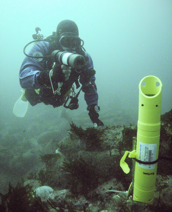
Fig 1: Diver with the Homer Pro and yellow transponder beacon on the Firebrand site
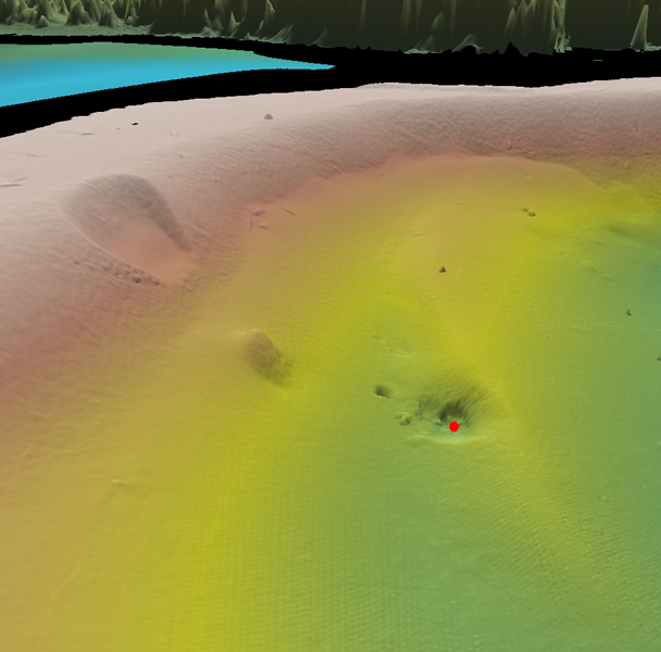
Fig 2: 3D Multibeam sonar image of the Catharina wreck site at the bottom of the southern slope in the Barnpool (red dot)
Array Box-in: Positioning in the Real World
Offshore survey equipment manufacturer Sonardyne International Ltd. had developed a technique for positioning seismic cables on the seabed so this method was adapted for positioning the site. This method called 'array box-in' would calculate position errors as well as positions, so we could also show how accurately the control points had been positioned. The array box-in method has since been used for positioning other sites such as the Mary Rose, the Resurgam submarine and the Coronation (1691) but it was used first on this site.
For the next stage a transceiver unit was fitted to the survey boat that could be used to interrogate the transponder beacons and measure the distance to them. The survey boat was also fitted with a survey processing computer and a differential GPS (DGPS) receiver. The transceiver unit on the boat could measure the distance from itself to the beacons by sending and receiving acoustic signals, pulses of sound which travel through water. The beacons send back a reply signal pulse in response to an interrogating signal pulse from the unit on the boat. The time between sending the interrogation and receiving the replies from the beacons is measured by the interrogating unit and then these times were sent to the processing computer.
The positioning survey was done on 13th August 1996 and took 12 minutes to complete. The survey boat was sailed around the outside of the site and the interrogating unit was set to periodically measure the distance to the beacons and send the results to the computer. The computer used these distances, the previously measured distances between beacons along with positions from the DGPS receiver to calculate where the beacons were. The computer could also calculate the accuracy of the positions of the points.
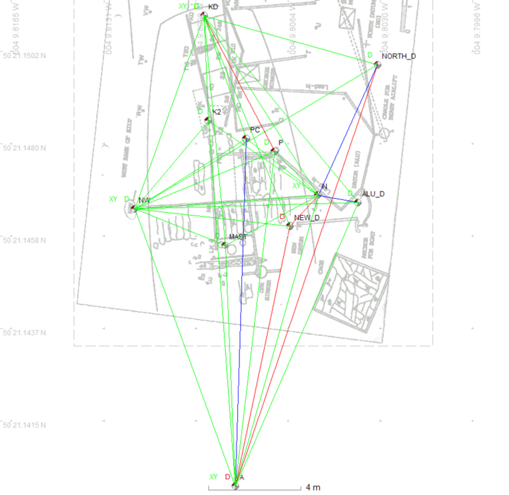
Fig 3: Acoustic range measurements between the existing survey control points
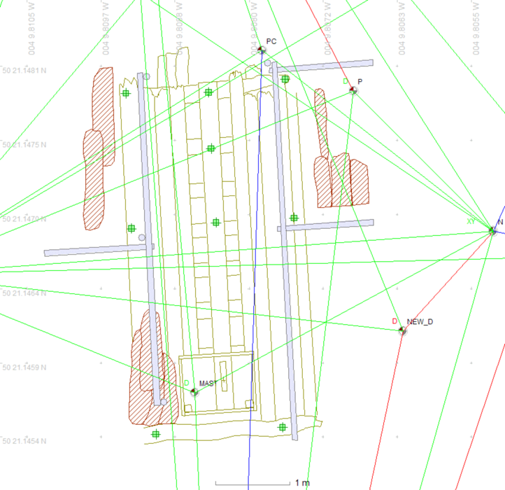
Fig 4: Acoustic range measurements shown over the hull timber drawing
Results
The survey data was processed using Site Recorder, this program can use measurements from a Homer Pro as well as tape measurements but it can also take in positions calculated using the array box-in method. All position, depth and distance measurements were processed together and used to compute positions for the control points. Eleven control points were positioned in three dimensions using 736 surface position fixes from the differential GPS, 42 acoustic baseline measurements from the Homer Pro and 11 depth measurements.
The processing software showed that the error in the Homer Pro measurements was 35mm, by comparison tape measurements less than 20m in length usually show a standard error of around 30mm. Positions of the points were accurate to approximately 0.5m absolute (95%) and 35mm relative to each other. The absolute accuracy is governed by the accuracy of the 'top-down' positioning technique whereas the relative accuracy is largely defined by the accuracy of the measurements made by the Homer Pro. This is a typical result for a positioning exercise carried out with this equipment.
The shape of the control point network was not ideal. The measurements to Point A to the south of the site meet at a very acute angle making the network rather pointed in shape. This network could be improved by placing another control point between CPs A and ALU_D. More about network design...
Conclusions
- The Sonardyne Homer Pro has a similar measurement accuracy to a standard fibreglass tape measure.
- Making distance measurements with the Homer Pro is quicker than using a tape measure. The time taken to complete this survey was considerably less than that required for a tape survey under the same conditions. The distance measurements using the Homer Pro were collected in just two 40 minute dives on the site.
- On this particular site it was easier to use a Homer Pro than a tape measure. The site is in 30m of low visibility water with currents cutting across the site. In addition, the wreck is down in an excavation hole below seabed level and is covered by a scaffold frame. There is a large chance that any tape measures will be snagged on the scaffold frame in these conditions and it is not feasible to use more than one tape at once. The Homer effectively acts as a tape measure to each beacon on the seabed yet it can easily be used in such conditions.
Related Pages
- 3D Trilateration
- Acoustic positioning systems
- Sonardyne Homer Pro Locator
Bibliography and Links
- Holt P., 1996, Positioning of Site S051 ‘Fraumetta Catharina‘ Barnpool, Plymouth Sound, UK. Survey Report, PMARIG, Ref. S054
- Skelton, Ian, 2010: Die Frau Catharina von Flensburg: A Danish Brigantine Wrecked In 1786 In Plymouth Sound, England, International Journal of Nautical Archaeology (2010) 39.2: Blackwell, Oxford
- Catharina (1786) on the SHIPS Project web site
- The wreck of the Metta Catharina at Mount Edgcumbe House